Tags
The next few posts will be dedicated to my PhD dissertation dealing with pedestrian movement in different urban contexts. The paper containing my dissertation’s major findings has been accepted for publication in the journal – “Computers, Environment and Urban Systems” – and for a limited time is available for free. The paper was written together with my advisor, Itzhak Omer, under the title:
Urban Area Types and Spatial Distribution of Pedestrians: Lessons from Tel Aviv
Essentially, this study aims to examine what conditions lead to greater pedestrian movement in urban space. To achieve this goal we have quantified various attributes of the built environment and then checked their statistical association with the level of observed pedestrian movement. The research was carried in four different areas in the city of Tel Aviv. Each of those areas was split into a traditional urban area and a contemporary one, reflecting the major shift that occurred during the 20th century in urban planning from a humanistic discipline to a technocratic one. In this sense Tel Aviv is an ideal case for such an investigation containing both contemporary and traditional urban areas in close proximity.
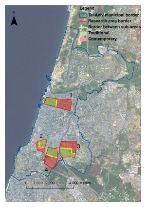
This post will focus on the observed pedestrian movement volume and the retail fronts distribution. First, let’s have a look at the chosen research areas and their division to traditional and contemporary urban areas. The map below shows the research areas in the context of the city of Tel Aviv (click to enlarge):
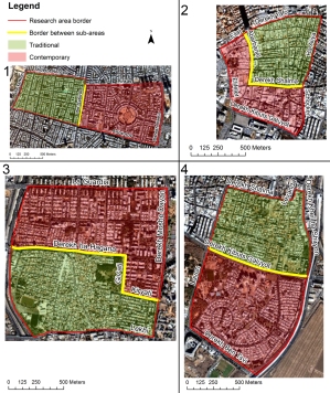
The close up aerial photos below show clearly the differences in the street network between the traditional connected areas to the contemporary less connected areas:
The first area (marked with the number) is centered on Ibn Gabirol Street, which is one of the major commercial streets in the city. The second area comprises of Florentine Neighborhood. In these areas both the traditional and contemporary parts were planned, yet they differ significantly in the connectivity levels and in land use composition. In both cases the contemporary area is a super-grid of the older traditional area next to it. In addition, Florentine’s contemporary area was planned as an industrial area and as a result have a rather low residential density.
The third area comprises of the neighborhoods of Hatikvah (traditional) and Yad Eliyahu (contemporary), while the fourth area is made of the neighborhoods of Shapira (traditional) and Kiriyat Shalom (contemporary). In both of these case the traditional neighborhoods were unplanned in some sense and had a bottom-up process of generation. In contrast, both of their contemporary counterparts were planned from the top in the fashion of early modernistic planning after the second world war.
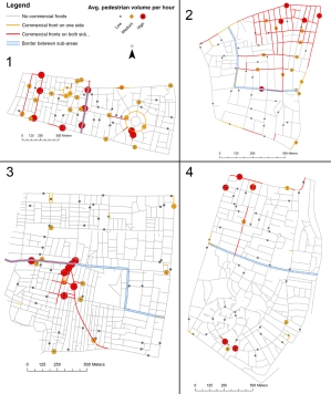
The following map shows our findings regarding observed pedestrian movement volume and retail fronts distribution in all of the research areas. The pedestrian movement volume is distributed in a heavy-tailed way, meaning that there are only a few streets that carry a lot of movement while most of the streets carry low movement volumes. To visualize this we have emphasized the points where the top 10% of pedestrian movement was observed with red points and the next 20% are highlighted using orange points. In this context, heavy pedestrian movement means over 400 pedestrian per hour and medium movement rate means stands for over 200 pedestrians per hour. As for retail distribution – streets sections in which both sides have retail are marked with red lines, while streets with only one side of retails are marked with orange lines.
Basically, the traditional areas have a more connected street network, with a higher presence of retail fronts and a higher volume of pedestrian movement. Moreover, even in the traditional sub-area where the lowest pedestrian movement volume was observed (which is Shapira Neighborhood in the top of area number 4), the average movement volume per road segment was higher still than that in the contemporary sub-area with the highest pedestrian movement volume (which is the eastern Ibn Gabirol area – to the right of area number 1). Pedestrian movement is higher in that traditional area even though the residential and employment densities are lower than that of the contemporary sub-area.
It can be clearly seen that in all traditional urban area commercial streets have successfully developed, while in the contemporary urban areas no commercial streets managed to grow. This happened regardless of municipal regulations that sometimes tries to prohibit commercial development and at other times tries to promote it. The commercial streets have all developed along the most central streets. Over the fine grid of Florentine (top-right in area number 2) an extensive grid of commercials street had sprouted from the top-right intersection, which is a rather central intersection in the city of Tel Aviv.
In conclusion, urban commerce does not happen based on an abstract will of a planner, but is the result of certain conditions, where the most important aspect is the road network, its intensity and the centrality it provides to certain streets. The next post will deal with the statistical associations themselves between commerce, street centrality and pedestrian movement. In addition, these findings are in line with other studies on the growth of urban commercial activity. Recommended reading on this subject include the following papers, which are free to access:
“The effects of block size and form in North American and Australian city centres” by Arnis Siskna. This paper examines 12 CBDs of North-American and Australian cities and reaches findings on land use formation based on the street network and morphological structure. Siskna points to the spontaneous development of urban commerce in the shape of a spiky potato.
Another and better known paper extends Siskna’s findings: “Centrality as a process: accounting for attraction inequalities in deformed grids” by Bill Hillier. In this paper Hillier suggests several insights regarding the development of intense urban centers and the needed conditions for them.
And as previously mentioned, you can find my new paper which further confirms and extends on Hillier’s work here.


Pingback: Pedestrian Movement and the Built Environment in One Simple Diagram | Yet Another Urban Blog
Hello, thank you for your interesting research. How did you collect the data about the pedestrian movement in the city?
The extended method appears in the full paper. Basically, we have counted pedestrians at all survey points concurrently for each of the four areas for 5 hours (10 minutes for each hour) for hours 15:00-20:00 on a regular weekday with good weather (spring time).
Thank you!