Transportation means are drivers of urban development. Highways and interchanges induce low density sprawl, while rail stations can induce intense urban and economic development in their vicinity. But like everything else related to planning – urban space is not homogeneous – some places are more central with higher development potential and some less so. Potential assessment can therefore help and guide major planning decisions.
This post is an explanation of a study we did on rail stations and which was presented at the last Space Syntax Symposium in Lisbon last summer. The full paper itself can be found here. At the time, we had to deal with the issue of Binyamina’s train station moving westward in the coming 10-15 years (one of Israel’s mid-size train stations) and this led us to ponder how can the development potential around rail stations be assessed.
To tackle this issue, we synthesized Luca Bertolini’s qualitative studies with Bill Hillier’s quantitative studies. Bertolini has wrote extensively about the significance of train stations and the ways they should be planned to achieve goals such as efficient use of infrastructure and land development. Basically, he points out the fact that a train station is a place where large scale movement (train trips of ten and hundreds of kilometers) meet with small scale movements of pedestrians (movements of few hundred meters) at differing intensity levels. In addition, due to the physical characteristics of the trains themselves, the train stations are usually a barrier to pedestrian movement and cause interruptions in urban space. Therefore, planning a successful train station is a work of art with regards to entrances, exits and fitting in the surrounding space. There are stations where the centrality of the rail network combines with other factors which lead to extensive burden on the land in and out of the station (HaShalom station is a station like that in Israel, but Amsterdam central station and Koln central station show that such stations can be both very intensive and successful), while most stations have much lower intensities. Hillier focuses of analysis of spatial networks based on space syntax (a method in which we at PlaNet specializes at). Combining both approaches allows for some kind of standardization and quantification of Bertolini’s concepts in order to integrate these concepts in urban and transport planning.
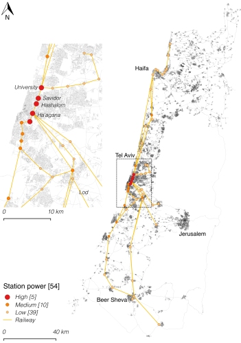
For the analysis of Israel train stations we have mapped the entire road network of Israel and its 54 train stations. In order to correlate the model we received from Israel Railways the number of average daily passengers for each station. We have found a satisfactory correlation at the 100 km scale, and we still have work to do with regards to edge stations (that get more passengers that what our model predicts). In the following map the model for assessing trains stations centrality (in the rail network) is shown with three categories – strong, medium and weak stations. Most of the train stations (70%) are weak, while a few (10%) are strong. Tel Aviv’s four stations are obviously strong, while Holon Junction is fifth, which points to a missed opportunity as most of the land around it is not developed at all. The most interesting stations are the medium stations (20%), since they have development potential that can materialize with good planning. The current Binyamina station is among those station and has neighboring employment center that got built against all odds.
In order to combing rail movement with pedestrian movement we have employed two more computational steps. We have spread the rail strength index among all segments up to 700 m (pedestrian network distance) based on literature. Furthermore, we have employed a centrality index at 1,250 m radius to give a proxy for pedestrian movement intensity (based on correlated models for pedestrian movement in Israel). All these indices where multiplied together to create a single map which reflects train stations areas development potential.
When analyzing Tel Aviv central area, it is found that the HaHagana station has the largest gap between its centrality potential and the built environment intensity around it. This is also the only station in Tel Aviv where there if free parking, which hints at the inefficient land exploitation. Another station with hidden potential is Yoseftal station which lies between Bat-Yam and Holon. Fortunately, Bat Yam municipality is making plans for intensification and we assume that Holon has something similar in its sleeve.
The model presented here is a first step in creating quantitative methods for spatial potential assessment of train stations. In the next steps motorized movement and light rail can also be incorporated in order to keep improving the model. The use of such models would allow for identifying places with hidden potential – places where planning efforts would the deliver the most benefits. Such models can also be used when planning new train stations and when relocating existing stations to evaluate the optimal location.
In conclusion, the study presented here is a first of its kind in the scope and analysis for train stations and I hope it will inspire further studies and would also have a real impact in planning. For those interested in delving deeper – the entire paper with all the explanations and reservations can be found here.


