• About
  • Contact
  • Research & Publications
  • The Blog’s Map
  • Press

Yet Another Urban Blog

~ Yoav Lerman's Blog

Yet Another Urban Blog

Tag Archives: Train

Assessing Rail Stations Development Potential

26 Sunday Nov 2017

Posted by Lerman in Israel, Transportation

≈ Leave a comment

Tags

Bertolini, Hillier, Rail, space syntax, Station, Train

Transportation means are drivers of urban development. Highways and interchanges induce low density sprawl, while rail stations can induce intense urban and economic development in their vicinity. But like everything else related to planning – urban space is not homogeneous – some places are more central with higher development potential and some less so. Potential assessment can therefore help and guide major planning decisions.

This post is an explanation of a study we did on rail stations and which was presented at the last Space Syntax Symposium in Lisbon last summer. The full paper itself can be found here. At the time, we had to deal with the issue of Binyamina’s train station moving westward in the coming 10-15 years (one of Israel’s mid-size train stations) and this led us to ponder how can the development potential around rail stations be assessed.

To tackle this issue, we synthesized Luca Bertolini’s qualitative studies with Bill Hillier’s quantitative studies. Bertolini has wrote extensively about the significance of train stations and the ways they should be planned to achieve goals such as efficient use of infrastructure and land development. Basically, he points out the fact that a train station is a place where large scale movement (train trips of ten and hundreds of kilometers) meet with small scale movements of pedestrians (movements of few hundred meters) at differing intensity levels. In addition, due to the physical characteristics of the trains themselves, the train stations are usually a barrier to pedestrian movement and cause interruptions in urban space. Therefore, planning a successful train station is a work of art with regards to entrances, exits and fitting in the surrounding space. There are stations where the centrality of the rail network combines with other factors which lead to extensive burden on the land in and out of the station (HaShalom station is a station like that in Israel, but Amsterdam central station and Koln central station show that such stations can be both very intensive and successful), while most stations have much lower intensities. Hillier focuses of analysis of spatial networks based on space syntax (a method in which we at PlaNet specializes at). Combining both approaches allows for some kind of standardization and quantification of Bertolini’s concepts in order to integrate these concepts in urban and transport planning.

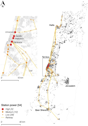
For the analysis of Israel train stations we have mapped the entire road network of Israel and its 54 train stations. In order to correlate the model we received from Israel Railways the number of average daily passengers for each station. We have found a satisfactory correlation at the 100 km scale, and we still have work to do with regards to edge stations (that get more passengers that what our model predicts). In the following map the model for assessing trains stations centrality (in the rail network) is shown with three categories – strong, medium and weak stations. Most of the train stations (70%) are weak, while a few (10%) are strong. Tel Aviv’s four stations are obviously strong, while Holon Junction is fifth, which points to a missed opportunity as most of the land around it is not developed at all. The most interesting stations are the medium stations (20%), since they have development potential that can materialize with good planning. The current Binyamina station is among those station and has  neighboring employment center that got built against all odds.

Train stations and their evaluated strength

In order to combing rail movement with pedestrian movement we have employed two more computational steps. We have spread the rail strength index among all segments up to 700 m (pedestrian network distance) based on literature. Furthermore, we have employed a centrality index at 1,250 m radius to give a proxy for pedestrian movement intensity (based on correlated models for pedestrian movement in Israel). All these indices where multiplied together to create a single map which reflects train stations areas development potential.

When analyzing Tel Aviv central area, it is found that the HaHagana station has the largest gap between its centrality potential and the built environment intensity around it. This is also the only station in Tel Aviv where there if free parking, which hints at the inefficient land exploitation. Another station with hidden potential is Yoseftal station which lies between Bat-Yam and Holon. Fortunately, Bat Yam municipality is making plans for intensification and we assume that Holon has something similar in its sleeve.

Close up of the results at the network’s center

The model presented here is a first step in creating quantitative methods for spatial potential assessment of train stations. In the next steps motorized movement and light rail can also be incorporated in order to keep improving the model. The use of such models would allow for identifying places with hidden potential – places where planning efforts would the deliver the most benefits. Such models can also be used when planning new train stations and when relocating existing stations to evaluate the optimal location.

In conclusion, the study presented here is a first of its kind in the scope and analysis for train stations and I hope it will inspire further studies and would also have a real impact in planning. For those interested in delving deeper – the entire paper with all the explanations and reservations can be found here.

  • Facebook
  • Twitter
  • Email

Like this:

Like Loading...

How to Upgrade the City Center and Stay Alive – the Case of Utrecht

16 Thursday Oct 2014

Posted by Lerman in Holland, Urbanism

≈ 8 Comments

Tags

Station, Train, Utrecht

What is Utrecht? Utrecht is just another Dutch city, a generic Dutch place if you will. Not really important, not really interesting and not really pretty. Lots of bicycles, rain and Dutch food. Holland in its most common form. So what is special about this not so special place? Utrecht currently leads one of the most complex projects I have come across, and it does so rather successfully.

At the foundation of this urban program called CU 2030 (the target year of the program, which has a bilingual website and a Facebook page) stands the central train station, which is also the largest train station in The Netherlands (due to Utrecht’s location). The train station consists of 14 platforms and almost 300,000 passengers pass through it every day. As part of the program, the station is being expanded to 19 platforms and on top of it dozens of construction and transportion projects are taking place all around. Here is what they say (I’ve highlighted the section that deals with the program partners):

Utrecht is building a new Station Area. This was much needed; ever since the Hoog Catharijne shopping mall was built in the 70s there had been overdue maintenance, neglect, a growing number of passengers, a growing city and the desire to get water back in the old canal. With the contruction of a new and renenewed area all these things are tacled at once.

The historic inner city and the Station Area were two seperated parts of Utrecht; these parts will be connected again to form one coherent centre. Liveliness and safety will be improved. There will be space for culture, leisure, the area will be better accessible and last but not least: water will flow once again in the canal that was filled in during the 70’s.

We’re building a future that’s sustainable: low emission buildings, plenty of pleasant space for bikes, public transport and pedestrians, and solar cells on top of the platforms.The building of the Utrecht Station Area is a close co-operation between the City of Utrecht, Corio (owner of Hoog Catharijne mall), Dutch Rail, ProRail and the Jaarbeurs (tradefair).

You can notice that this complex program involves five major partners – the municipality, the mall that is conencted to the train station and goes by the name Hoog Catharijne (we’ll get to it shortly), both of the Dutch rail companies and the fair grounds. There is no single boss that dictates everything for everyone. Like in many other places, The Dutch built many bad malls in the 1970s, and one of them was placed on Utrecht’s central train station. In fact, to exit from the station to the city center, one must go through the mall (also at night when all the shops are closed). The mall itself has an incoherent internal structure, which became pretty unsafe over the years until they had to shut down the upper floor entirely. As part of the train station upgrade the internal strcuture of the mall is modified so as to make a cleaner and more navigable space eventually. Before we delve further, here is a fantastic clip that explains almost everything:

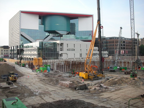
The Dutch work on a grand scale. This is not a transportation plan nor a construction plan. This is solid urban planning that goes beyond just construction and transportation and includes also contact with the various stakeholders (including the residents), financing and execution. An important aspect is the day to day project management itself. The entire area of the train station lies in a complete disarray, yet the station and its shops are open for business, the mall works and accessibility for bikes, pedestrians and public transit is provided all throughout the project (even though it’s a little bit messy for Holland). The program has an information center open to public, which also provides guided group tours. Yep, the guys from Utrecht city hall do not hide beyond blank walls like is common in other countries.

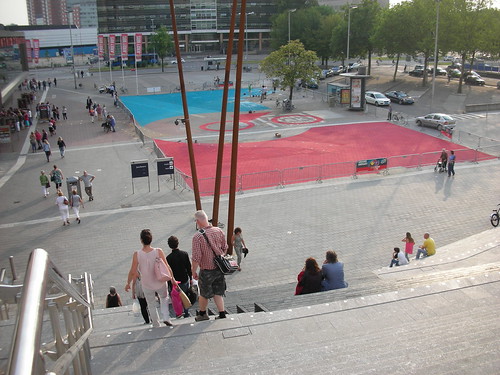
The new bike parking strcuture is used for seating and relaxing in front of the new square outside of the train station. The 2015 Tour de France will start here.

Jaarbuers Stairs and Bike Parking in Utrecht

The clip shown above was uploaded to the web last March. I visited the Utrecht during the month of July and it appeared to be going as planned. The new concert hall (Tivoli Vredenburg) next to station was already open. The luxurious bike parking strcture, including over 4,700 spaces is in operation, and serves as a convenient platform for relaxing. Overall, more than 30,000 bike parking spaces are planned to built around the station area (and it will not be enough). The new city hall is just about ready. You can see the other projects around the station, including daylighting of a canal that was covered during the 1970s (when even the Dutch thought that the city needs as much asphalt as possible).

Not a dull moment. The new concert hall in the background.

Tivoli Vredenburg Halls

This post demands further discussion on the lessons that can be learned from this urban program. In the meantime, you can keep calm and know that there are public organizations that plan, manage and execute big and complex urban projects. And they do it while sticking to schedule, holding a public discussion and in the right place.

For your convenience, here is a map of Utrecht and its central train station (which is located on the western edge of the old city):

  • Facebook
  • Twitter
  • Email

Like this:

Like Loading...

RSS

Enter your email address to follow this blog and receive notifications of new posts by email.

Recent Posts

  • Assessing Rail Stations Development Potential
  • Using Space Syntax for Decision Making in Urban Planning
  • Toward an Efficient and Sustainable Urbanism
  • Freiburg’s Way
  • Pedestrian Movement and the Built Environment in One Simple Diagram

Recent Comments

  • Ashton on Israeli Planning is Homogeneous and Wasteful
  • Colin mcdonald on Cumbernauld – the Worst Place Ever Planned
  • Single Family Homes in Suburbs Ever More Popular as Downtown Affordability Wanes - ICG Real Estate Investments on Christopher Leinberger and the Urban Option
  • Single Family Homes in Suburbs Ever More Popular as Downtown Affordability Wanes – ICG Real Estate Investments on Christopher Leinberger and the Urban Option
  • chen on Where People Go and Commercial Streets Grow

Category Cloud

Academia Belgium Book Britain Criticism General Germany Holland Housing Israel Land-Use Parking Planning space syntax Tel Aviv Transportation Urbanism USA

Archives

Global Urbanism

  • CityLab
  • Copenhagenize
  • Failed Architecture
  • Human Transit
  • Pedestrian Observations
  • Strong Towns
  • The Guardian Cities
  • This Big City

Enter your email address to follow this blog and receive notifications of new posts by email.

Blog at WordPress.com.

  • Follow Following
    • Yet Another Urban Blog
    • Join 25 other followers
    • Already have a WordPress.com account? Log in now.
    • Yet Another Urban Blog
    • Customize
    • Follow Following
    • Sign up
    • Log in
    • Report this content
    • View site in Reader
    • Manage subscriptions
    • Collapse this bar
 

Loading Comments...
 

    %d bloggers like this: