I am glad to share with you a paper that I have co-authored and which was published recently in the International Journal of Geographic Information Science. The paper was written by Prof. Itzhak Omer of Tel Aviv University, Dr. Yodan Rofè of Ben-Gurion University and myself. The full title of the paper is:
“The impact of planning on pedestrian movement: contrasting pedestrian movement models in pre-modern and modern neighborhoods in Israel”
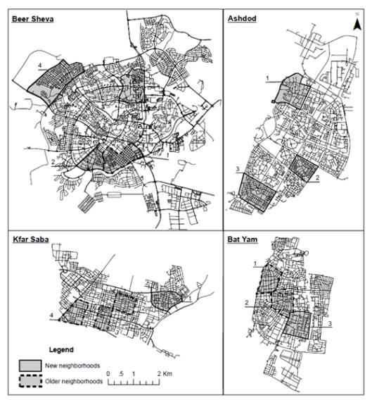
As evident from the name of the paper, this publication deals with the impact of planning on pedestrian movement. We analysed pedestrian movement in 14 neighborhoods in four different cities in Israel – Kfar Saba, Bat Yam, Ashdod and Beer Sheva. These neighborhood where divided to two categories – modern and pre-modern. Essentially, modern neighborhood are those that were planned along modernistic urban planning approach, which adheres to separation of uses and hierarchical road structure. In contrast, pre-modern planning which tends to be denser with a lot more mix of uses and less hierarchical road structure. Basically, all the neighborhoods planned after the establishment of the state of Israel (1948) are modern, while most of the neighborhoods that were established prior to the Israeli state independence are pre-modern. Moreover, the cities of Bat Yam and Kfar Saba have many more pre-modern parts than the cities of Beer Sheva and Ashdod (this city was established in 1956 and consist only of modern planning).
Following are the maps of all the research neighborhoods in their respective cities. Dashed lines mark pre-modern neighborhoods while continuous lines mark modern neighborhoods.
We did pedestrian movement surveys in all the research neighborhoods and examined the statistical correlations of the movement volume with relevant quantifiable variables that describe the built environment. For the analysis of the road structure we have relied heavily on space syntax. Other variables were derived from land use distribution – especially retail and demographic variables such as population densities.
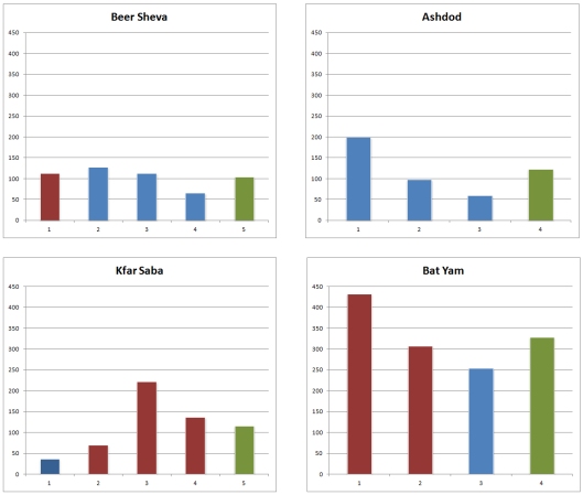
Significant disparities in pedestrian movement volume were found among the cities and among the different neighborhoods. The pre-modern neighborhoods had about twice the pedestrian movement volume of the modern neighborhoods on average. Also, retail fronts were found to be much more prevalent in pre-modern neighborhoods than in modern neighborhoods. The chart below shows the average pedestrian movement volume (per hour) observed in the surveyed road section in all research neighborhoods. In red are the pre-modern neighborhoods, blue signifies the modern neighborhoods and green represents the average for each city. The city of Bat Yam, which is one of the denseset municipalities in Israel has remarkably higher movement volume than the other three cities.
Average pedestrian movement volume per hour in the surveyed road section in all research neighborhoods. Red is for pre-modern neighborhoods, blue for modern neighborhoods and green for entire city average.

Furthermore, our extensive statistical correlations showed that movement in pre-modern neighborhoods is far more predictable than in modern neighborhoods. At the last phase of this study we tried to produce a generic movement model for each type of neighborhood. To validate this model we analysed pedestrian movement in four more neighborhoods in Kfar Saba and in another city called Hod Hasharon (one neighborhood of each type in each city). The model had far more success in the pre-modern neighborhood than in the modern ones.
Besides addressing the issue of pedestrian movement in modern and pre-modern neighborhoods, the paper adds significant findings related to space syntax and the usability of its various attributes. For example, metrically derived attributes (based on metric distance and not on topological and angular distance) were found to be extremely inconsistent. The main conclusion I take from this work is quoted below:
Our study shows that traditional pre-modern urban neighborhoods, with a well-connected street structure, are likely to have not only more walking within them but also a more predictable spatial distribution of pedestrian volume than modern neighborhoods, that are characterized by hierarchical tree-like street layout associated with the idea of the neighborhood unit. We have identified that the correlation of pedestrian volume with the street network’s configuration attributes are significantly higher in pre-modern urban neighborhoods than in the modern neighborhoods. Furthermore, our study revealed that the distribution of pedestrian volume in these neighborhood types interacts differentially with the street network. In modern street layouts, the different types of configuration attributes (topological, angular, and metric) tend to be much more varied in their correlation with pedestrian volume across scale.
The full paper provides all the results and findings, expands on the use of space syntax in this research and describe in detail the statistical methods employed. You can find the full paper here, and if you cannot access the full paper and would like to read it you can contact me here and I’ll send you a copy.

